
Denison Mines Corp. (TSX: DML) (NYSE American: DNN) is pleased to report that drill hole WF-74A intersected 4.75% eU3O8 over 13.3 metres (0.05% eU3O8 cut-off), including a sub-interval grading 25.23% eU3O8 over 0.5 m, as part of the recently completed summer exploration program at the Waterfound River property.
Uranium mineralization was encountered in three of the seven drill holes completed during the summer exploration program, following up on the winter 2022 discovery of high-grade mineralization approximately 800 metres to the west of the Alligator Zone. The discovery from the winter 2022 program was highlighted by drill hole WF-68, which returned a mineralized interval of 5.91% eU3O8 over 3.9 metres (see press release dated March 29, 2022). Figure 1 and Figure 2 depict the location of the Alligator Zone and the 2022 summer drilling, respectively.
Andy Yackulic, P. Geo., Denison’s Director, Exploration, commented, “The mineralized intersection from WF-74A represents the best mineralized hole drilled on the Waterfound property to date, and highlights the potential for the discovery of additional high-grade uranium mineralization further along strike to the west of the Alligator Zone. The mineralization in WF-74A appears to be offset to the north when compared to the interpreted location of mineralization previously discovered in WF-68. This offset is notable, as it potentially indicates that a later, cross-cutting fault may be present between WF-74A and WF-68. The area to the west of WF-74A is sparsely drilled, thus leaving several kilometres of the fertile La Rocque conductive corridor open for follow up.”
Denison has an effective 24.68% ownership interest in the Waterfound River Joint Venture to which each of Orano Canada Inc. Denison, and JCU (Canada) Exploration Company, Limited are participants. Orano Canada has a 62.42% interest in the Waterfound JV and is the project operator.
2022 Waterfound River Summer Exploration Program Highlights
Drill hole WF-74A was completed approximately 40 metres west of WF-68 and intersected a broad zone of uranium mineralization grading 4.75% eU3O8 over 13.3 metres (0.05% eU3O8 cut-off), hosted within faulted Athabasca sandstone. The mineralization in WF-74A represents the best mineralized intersection drilled to date on the Waterfound property, and is highlighted by multiple narrow intervals of high-grade uranium hosted within fault strands, interpreted to represent the brittle reactivation of the D-1 conductor.
At the conclusion of the summer drill program, the mineralization intersected in WF-74A remains open along strike to the west and across strike in both directions. Additional drilling is required in this area to resolve the structural controls on the high-grade mineralization in WF-74A.
Drill holes WF-73 and WF-73-1 were drilled to test the D-1 conductor approximately 300 m along strike to the east of high-grade mineralization discovered during the 2022 winter drilling program in drill hole WF-68. WF-73 intersected perched uranium mineralization approximately 5 metres above the unconformity, grading 0.09% eU3O8 over 0.2 metres. The follow up hole, WF-73-1, successfully intersected uranium mineralization (0.34% eU3O8 over 1.6 metres) located immediately above the unconformity contact.
The mineralized intersections from the 2022 summer exploration drilling program are illustrated in Figure 2 and summarized in Table 1 below.
Table 1 – 2022 Waterfound River Summer Exploration Drilling Highlights
| Drill Hole | Orientation (azi./dip) | From (m) | To (m) | Length (m)(1) | eU3O8 (%)(2) | |
| WF-73(3) | 158°/-69° | 461.7 | 461.9 | 0.2 | 0.09 | |
| WF-73-1(3) | 158°/-67° | 470.1 | 471.7 | 1.6 | 0.34 | |
| WF-74A(3) | 155°/-69° | 479.2 | 492.5 | 13.3 | 4.75 | |
| including(4) | – | 484.0 | 484.5 | 0.5 | 25.23 | |
| and(4) | – | 487.7 | 488.6 | 0.9 | 14.35 | |
| and(4) | – | 490.2 | 490.5 | 0.3 | 16.30 | |
| and(4) | – | 491.8 | 492.0 | 0.2 | 17.52 | |
| Notes: | (1) Lengths indicated represent the down-hole length of mineralized intersections. | |||||
| (2) Radiometric equivalent U3O8 (“eU3O8“) derived from a calibrated gamma downhole probe. | ||||||
| (3) Mineralized interval is composited above a cut-off grade of 0.05% eU3O8. | ||||||
| (4) Mineralized interval is composited above a cut-off grade of 10.0% eU3O8. | ||||||
Overall, the 2022 summer exploration program consisted of seven completed diamond drill holes totalling 3,902.6 metres. Each of the holes completed during the summer drilling program intersected indicative alteration and structural disruption related to brittle-ductile deformation along the D-1 conductor trend. In addition, each of the holes encountered elevated radioactivity in the basal Athabasca sandstone, although only holes WF-73, WF-73-1, and WF-74A returned radiometric equivalent uranium grades exceeding 0.05% eU3O8.
Radiometric Equivalent Grades, Sampling, Analysis and Data Verification
Following the completion of a drill hole, the hole is radiometrically logged using a downhole slimline gamma probe, which collects continuous readings of radioactivity along the length of the drill hole. Probe results are then calibrated using an algorithm calculated from the comparison of probe results against geochemical analyses in the area. The gamma-log results provide an immediate radiometric equivalent uranium value (eU%, then converted to eU3O8%) for the hole, which, except in very high-grade zones, is reasonably accurate. The Company typically reports eU3O8, as a preliminary result and subsequently reports definitive assay grades following sampling and chemical analysis of the mineralized drill core.
Assay sample intervals are generally 50 centimetres long, except where higher or lower grade mineralization boundaries fall within the interval. In that case, two 25 centimetre samples are collected. Flank samples of 1.0 metre are always collected where mineralization is located. Systematic geochemistry samples are collected every 10 metres down the hole.
All assayed core is split in half, with one half retained and the other sent to the SRC Geoanalytical Laboratory in Saskatoon for analysis. Control samples are routinely assayed with each batch of core samples analyzed.
About Waterfound River
The Waterfound River property is located within the eastern portion of the Athabasca Basin region of northern Saskatchewan, approximately 40 kilometres northwest of Denison’s 22.5% owned McClean Lake mill. The Waterfound JV is an unincorporated contractual arrangement between Orano Canada (62.4223%), Denison Mines Inc. (11.7767%), and JCU (Canada) Exploration Company, Limited (25.8010%). Denison holds an effective 24.6772% ownership interest in the Waterfound JV through its direct interest in the joint venture and its 50% ownership of JCU.
About Denison
Denison is a uranium exploration and development company with interests focused in the Athabasca Basin region of northern Saskatchewan, Canada. The Company has an effective 95% interest in its flagship Wheeler River Uranium Project, which is the largest undeveloped uranium project in the infrastructure rich eastern portion of the Athabasca Basin region of northern Saskatchewan. Denison’s interests in the Athabasca Basin also include a 22.5% ownership interest in the McClean Lake joint venture, which includes several uranium deposits and the McClean Lake uranium mill that is contracted to process the ore from the Cigar Lake mine under a toll milling agreement, plus a 25.17% interest in the Midwest Main and Midwest A deposits, and a 67.01% interest in the Tthe Heldeth Túé (“THT”, formerly J Zone) and Huskie deposits on the Waterbury Lake property. The Midwest Main, Midwest A, THT and Huskie deposits are each located within 20 kilometres of the McClean Lake mill.
Through its 50% ownership of JCU, Denison holds additional interests in various uranium project joint ventures in Canada, including the Millennium project (JCU 30.099%), the Kiggavik project (JCU 33.8118%) and Christie Lake (JCU 34.4508%). Denison’s exploration portfolio includes further interests in properties covering ~300,000 hectares in the Athabasca Basin region.
Denison is also engaged in post-closure mine care and maintenance services through its Closed Mines group, which manages Denison’s reclaimed mine sites in the Elliot Lake region and provides related services to certain third-party projects.
Qualified Persons
The technical information contained in this release has been reviewed and approved by Mr. Andrew Yackulic, P. Geo., Denison’s Director, Exploration, who is a Qualified Person in accordance with the requirements of NI 43-101.
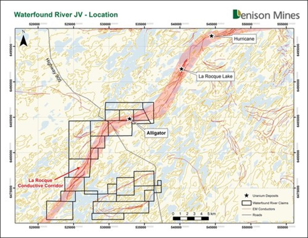
Figure 1 – Location – Waterfound River JV (CNW Group/Denison Mines Corp.)
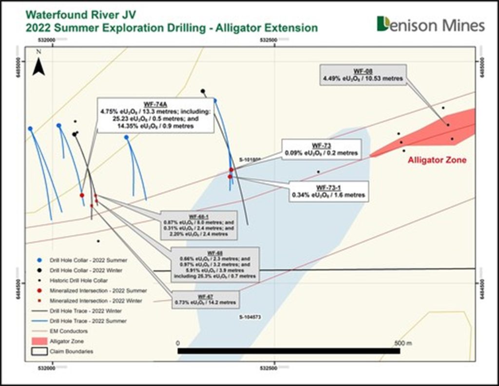
Figure 2 – 2022 Summer Exploration Drilling – Alligator Extension (CNW Group/Denison Mines Corp.)


